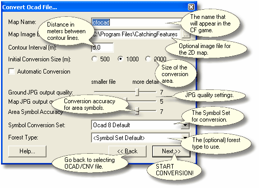
Map Name
The name that your CF map will be created as. This is for example the name that will appear in Single Player mode in the Catching Features game.
Map Image Export File
The filename of the JPG image exported from OCAD (300 DPI recommended) to use for the map image. If blank, the OCAD Converter will draw the map for you, but not all symbols will appear correctly. If a JPG is found with an identical name to the OCAD file, this field will be automatically filled-in.
Contour Interval
The contour interval of the map. The converter tries to guess, but if it's wrong you should correct it here. Please note that if you change the contour interval setting, you should most probably change some settings in the symbol set, since the default one is designed for 5 meter contours. Settings to consider are:
| • | Ground Height Randomness for main forest |
| • | Depth of depressions, pits and erosion gullies |
| • | Height of knolls and earth walls |
Initial Conversion Size
The size of the initial conversion rectangle.
| • | If you select Automatic Conversion, this is the maximum area that will be converted. |
| • | If you don't select Automatic Conversion, this is the initial size of the conversion area. This size can then be changed during the first step of the user-controlled conversion. |
Automatic Conversion
If this box is checked, the conversion will proceed without any user input.
If you uncheck this option, each step of the conversion will allow you to verify and correct any mistakes the converter may make.
Ground JPG output quality
This is the quality level of the ground bitmaps which contains the coloring of the ground. Generally, this setting can be set to a fairly low level, since the changes in quality hardly are noticeable at running speed.
Map JPG output quality
If you did not provide a Map Image Export File above, this is the quality level of the 2D map if JPG map chunks are created. Higher for a sharper map image, lower for a smaller file size. Since version 1.305, the converter will try to save the map chunks as PNG files, if they get smaller than the JPG counterparts. This setting will only be used for JPG map chunks, not for PNG map chunks.
Area Symbol Accuracy
The accuracy of borders of the area objects (such as borders of the vegetation areas) in the OCAD file. Set to a high value if accurate borders of the areas are important (will result in more triangles), set to a low value for smaller file.
Symbol Conversion Set
The symbol definition set that tells the OCAD Converter what to do with each symbol of the OCAD map. If you don't select Automatic Conversion, you can edit this set (or even select another set) at a later step. Since version 1.313, the converter will automatically select a symbol conversion file if it has the same name as the OCAD file.
Forest Type
The initial forest definition, if you want to select a forest type other than the one specified in the Symbol Conversion Set above.
Since version 1.313, the converter will automatically select a tree file if it has the same name as the OCAD file.
If you want to add your own forest type to this list, please look here.
The Help button will display a box with some help text.
The << Back button will take you back to the Ocad Convert selection window.
The Next >> button will start the conversion.
| • | If you have checked Automatic Conversion, the conversion will now be fully automatic until the resulting terrain is opened in the CF Editor. |
| • | If you haven't checked Automatic Conversion, a user-controlled OCAD conversion will now start. The conversion will go through 7 conversion steps, where you get the chance to change the required settings. |